Map Title
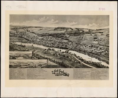
Fort Fairfield Maine 1893
Preview
Publication Date
1893
County
Aroostook
Artist
George E. Norris
Dimensions
28 x 52 cm
Owner
Norman B. Leventhal Map & Education Center at the Boston Public Library
Population of City/Town at Time of Publication
3,526
Description of City/Town
Fort Fairfield is located on the Aroostook River near its junction with the St. John River. The town takes its name from a fort built there in the 1830s as a result of the Northeast Boundary Dispute with Canada. In the post-Civil War period, potato farming thrived, resulting in starch factories processing one hundred thousand bushels of potatoes annually Other industries included sawmills and grist mills.
Historic Newspaper References
The Northern Leader, Fort Fairfield, August 4, 1893
A Sketch of Our Village. Mr. Geo. E. Norris of Brocton, Mass., is now engaged in preparing a sketch of Fort Fairfield. It will be 19 x 24 inches and will give every street and building with their exact location. Embracing all from, and including two or three buildings on Currier Street, as far as Cutts and Scates addition on High Street, as far East as the boundary, including the park and Riverside Avenue on the North side. The view is from the hill on the north side [of] the river, and we have not a doubt after examining sample work that Mr. Norris has with him that the sketch will be one that our citizens will be proud of, and that can be used with advantage in booming our village. All who are building, or are soon to make changes in their buildings, should see Mr. Norris that the sketch may be as perfect as possible when completed.
The Northern Leader, Fort Fairfield. August 25, 1893
Our Village. We have seen a finished copy of Mr. Norris’ Photogravure of the village of Fort Fairfield. This beautiful picture, beautiful because it is real, far exceeds our expectations. It not only gives the points of interest and prominent buildings, but is a correct finished picture of the entire village. From a careful study of the engravure a correct idea of our village may be secured, any given building readily located and Fort Fairfield of to-day brought clearly before ones vision. But this is not all of its use. Fort Fairfield of to-day and Fort Fairfield of the future will be two very different looking places. Then to see what we were and what we are, will give great satisfaction to its friends.
The Northern Leader, Fort Fairfield, September 29, 1893
Fort Fairfield Views. It is not often that men do better than they promise, and yet after a careful examination of Mr. George E. Norris splendid view of our village, we have not the least hesitation in saying, if he has not exceeded his own expectations he has ours. Mr. Norris came with “specimen of his work” and it was “good work and square work.” But either Fort Fairfield is a better village to sketch or more painstaking work has been done then his specimens warranted. A friend suggests that “practice makes perfect.” Truly this is a perfect sketch.
The Northern Leader, Fort Fairfield, September 29, 1893
Mr. W. H. Linton has secured the agency for the beautiful view of Fort Fairfield by Mr. Geo. E. Norris; this will be your only chance to get one and it should be in every house and office in town.
Usage Rights
High-resolution imagery for most maps and objects in our Digital Collections is available for download directly from each object’s record page in TIFF and JPEG format. Unless otherwise noted, all images are in the public domain and have no restrictions on use. We provide no warranty as to the copyright status of the objects themselves.
Recommended Citation
Courtesy of the Norman B. Leventhal Map & Education Center at the Boston Public Library
Link to Item at Home Institution
Keywords
Fort Fairfield, Aroostook County, Maine, Bird's eye, View, Map