
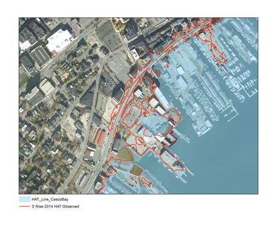
Observed highest annual tide (HAT) data were used to project a 3-foot sea-level rise line onto maps created for the Envisioning Change project. The maps show the impact of a 3-foot rise on the shoreline of Casco Bay (including Portland). In Fall 2014, students in a USM special topics art course, Shaping the Terrain: Sea-Level Rise in Casco Bay, demarcated this line in physical space through the King Tides Trail Installation. (Listen to the MPBN story on this project at http://news.mpbn.net/post/visualizing-climate-change-maine-artists-work-intends-spark-debate). Additionally, the 3’ line was marked with blue flags at an event called the King Tide Party, which took place in October of 2014 at MoonTide Garden, a public art site near the Ocean Gateway Terminal in Portland, Maine.
Printing is not supported at the primary Gallery Thumbnail page. Please first navigate to a specific Image before printing.


