• Home
  • Search
  • Browse All Collections
  • My Account
  • About
  • DC Network Digital Commons Network™
Skip to main content
USM Digital Commons
  • Home
  • About
  • FAQ
  • My Account

Home > Digital Humanities > ENVISIONING_CHANGE > CMAPS > CMATPE

Contemporary Maps

Apical Tidal Pond Extents

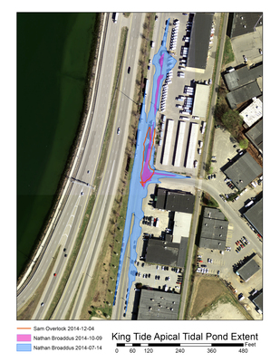
On July 14, 2014 between midnight and 2:00 a.m., USM graduate student Nathan Broaddus recorded the impact of a King Tide using a GeoXT Trimble GPS device. Through two perimeter walks he produced polylines approximating the flood outline on Marginal Way and Cove Street in Portland. He repeated the same process on October 9 to measure the tidal effect in a different month and show a seasonal variation, which proved to be significant. The blue area on the map shows the outline of the flood as traced in July, and the magenta area represents the shape in October. The red outline was traced in December 4, 2013 using a mobile mapping app.
Printing is not supported at the primary Gallery Thumbnail page. Please first navigate to a specific Image before printing.

Follow

Switch View to List View Slideshow
 
  • Marginal Way-Cove Street King Tide Apical Tidal Pond Extent by Nathan Broaddus

    Marginal Way-Cove Street King Tide Apical Tidal Pond Extent


Search

Advanced Search

  • Notify me via email or RSS

Author Corner

  • Author FAQ

Browse

  • All Collections
  • Authors
  • Disciplines

Gallery Locations

  • View gallery on map
  • View gallery in Google Earth

Links

  • USM Libraries
  • Digital Commons in Maine
Twitter Facebook Instagram
University of Southern Maine
 
Elsevier - Digital Commons
University of Southern Maine

Home | About | FAQ | My Account | Accessibility Statement

Privacy Copyright