

-
 by Maine Coast Heritage Trust")
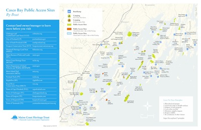
Casco Bay Public Access Sites By Boat (Map)
Maine Coast Heritage Trust
A map of sites that can be accessed in Casco Bay by boat.
-

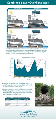
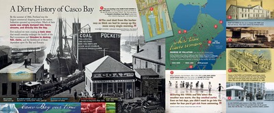
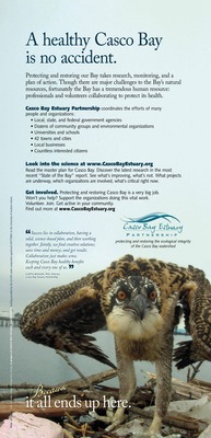
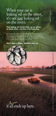
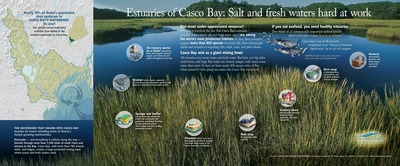
2015 State of the Bay Summary Flyer
Casco Bay Estuary Partnership
The Casco Bay Estuary Partnership helps track and report on changing conditions within the Bay and its watershed. Every five years, in its State of the Bay report, the Partnership portrays how Casco Bay is faring—what trends are evident, what progress is visible, and what new challenges are emerging. By tracking indicators at regular intervals over decades, the Partnership helps identify the collective work needed to sustain the region.
State of the Bay 2015, summarized here and detailed online at www.cascobayestuary.org/state-of-the-bay-2015, reveals a complex array of factors shaping the ecology and economy of the Casco Bay region. There’s a mix of encouraging news, interspersed with unsettling trends. The warming climate represents a vast and unpredictable driver of regional change—with hotter ocean and air temperatures, more frequent and extreme precipitation, and rising seas (already evident in flooding at extreme high tides).
Indicators used in the past (and included in the 2015 report) do not fully account for the dynamic interplay of forces currently at work on Casco Bay. Future reports will include new indicators to help gauge the pace and impacts of far reaching change.
-

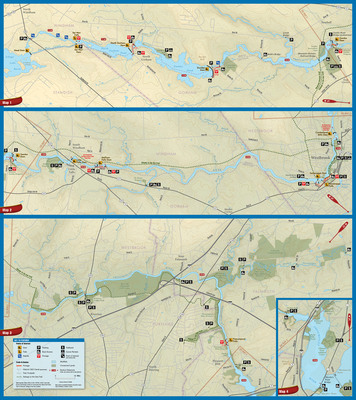
Presumpscot River Paddling Map & Guide
Casco Bay Estuary Partnership and Presumpscot River Watershed Coalition
Presumpscot River paddling map and text.
-
 by Hilary A. Neckles, Angela D. Brewer, John W. Sowles, Seth Barker, Curtis C. Bohlen PhD, Matthew Craig, Michael Doan, and Sandra Lary")
Update on a Continuing Saga: Eelgrass and Green Crabs in Casco Bay, Maine (Poster)
Hilary A. Neckles, Angela D. Brewer, John W. Sowles, Seth Barker, Curtis C. Bohlen PhD, Matthew Craig, Michael Doan, and Sandra Lary
-
 by Casco Bay Estuary Partnership, Presumpscot River Watershed Coalition, and Center for Community GIS")
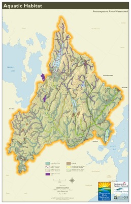
Presumpscot River Watershed Map: Aquatic Habitat (Map)
Casco Bay Estuary Partnership, Presumpscot River Watershed Coalition, and Center for Community GIS
-
 by Casco Bay Estuary Partnership, Presumpscot River Watershed Coalition, and Center for Community GIS")
Presumpscot River Watershed Map: Water Quality (Map)
Casco Bay Estuary Partnership, Presumpscot River Watershed Coalition, and Center for Community GIS
-

Sea Level Rise Planning for Bayside in Portland: A Community Discussion
New England Environmental Finance Center
How will sea level rise affect Portland’s Bayside neighborhood, and how should we respond? Join USM’s Environmental Finance Center to hear results from its recent study of potential lost real estate value in Bayside under various sea level rise, storm surge, and adaptation scenarios. Breakout discussions will focus on adaptation actions Portland might undertake. Your input will help frame Portland’s sea level rise adaptation planning process.
-
 by Presumpscot River Watershed Coalition, Casco Bay Estuary Partnership, and Center for Community GIS")
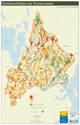
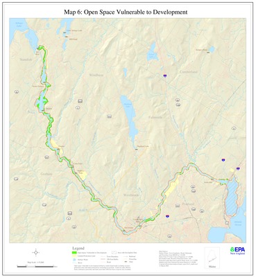
Presumpscot River Watershed Map: Combined Values for Conservation (Map)
Presumpscot River Watershed Coalition, Casco Bay Estuary Partnership, and Center for Community GIS
-
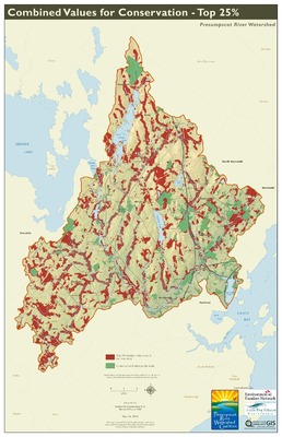
 by Presumpscot River Watershed Coalition, Casco Bay Estuary Partnership, and Center for Community GIS")
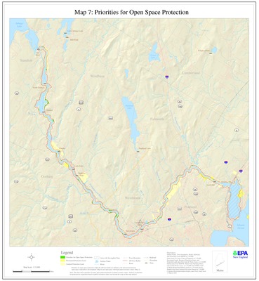
Presumpscot River Watershed Map: Combined Values for Conservation, Top 25% (Map)
Presumpscot River Watershed Coalition, Casco Bay Estuary Partnership, and Center for Community GIS
-
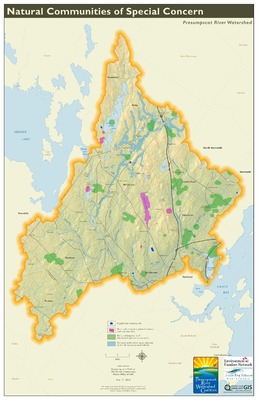
 by Presumpscot River Watershed Coalition, Casco Bay Estuary Partnership, and Center for Community GIS")
Presumpscot River Watershed Map: Natural Communities of Special Concern (Map)
Presumpscot River Watershed Coalition, Casco Bay Estuary Partnership, and Center for Community GIS
-
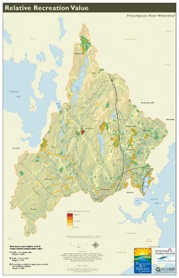
 by Presumpscot River Watershed Coalition, Casco Bay Estuary Partnership, and Center for Community GIS")
Presumpscot River Watershed Map: Relative Recreation Value (Map)
Presumpscot River Watershed Coalition, Casco Bay Estuary Partnership, and Center for Community GIS
-
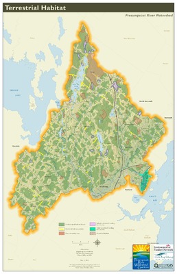
 by Presumpscot River Watershed Coalition, Casco Bay Estuary Partnership, and Center for Community GIS")
Presumpscot River Watershed Map: Terrestrial Habitat (Map)
Presumpscot River Watershed Coalition, Casco Bay Estuary Partnership, and Center for Community GIS
-
 by Presumpscot River Watershed Coalition and Casco Bay Estuary Partnership")
Presumpscot River Watershed Map: Historical Values (Map)
Presumpscot River Watershed Coalition and Casco Bay Estuary Partnership
-
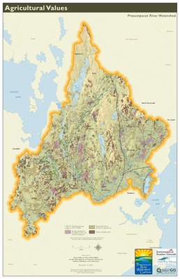
 by Presumpscot River Watershed Coalition, Casco Bay Estuary Partnership, and Center for Community GIS")
Presumpscot River Watershed Map: Agricultural Values (Map)
Presumpscot River Watershed Coalition, Casco Bay Estuary Partnership, and Center for Community GIS
-
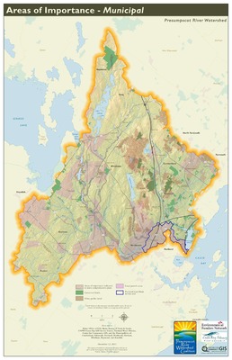
 by Presumpscot River Watershed Coalition, Casco Bay Estuary Partnership, and Center for Community GIS")
Presumpscot River Watershed Map: Areas of Importance-Municipal (Map)
Presumpscot River Watershed Coalition, Casco Bay Estuary Partnership, and Center for Community GIS
-
 by Presumpscot River Watershed Coalition, Casco Bay Estuary Partnership, and Center for Community GIS")
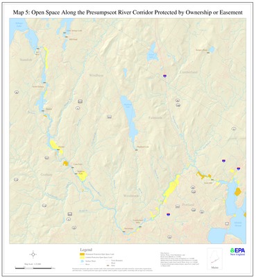
Presumpscot River Watershed Map: Conserved and Public Lands (Map)
Presumpscot River Watershed Coalition, Casco Bay Estuary Partnership, and Center for Community GIS
-
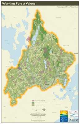
 by Presumpscot River Watershed Coalition, Casco Bay Estuary Partnership, and Center for Community GIS")
Presumpscot River Watershed Map: Working Forest Values (Map)
Presumpscot River Watershed Coalition, Casco Bay Estuary Partnership, and Center for Community GIS
Printing is not supported at the primary Gallery Thumbnail page. Please first navigate to a specific Image before printing.
 by Casco Bay Estuary Partnership")
 by Casco Bay Estuary Partnership")
 by Casco Bay Estuary Partnership")
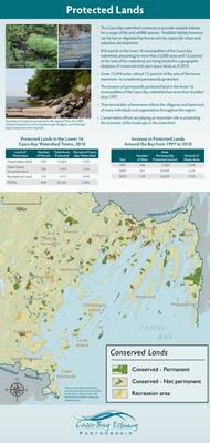
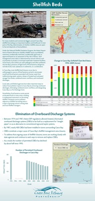
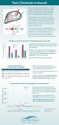
 (2010 State of the Bay Poster) by Casco Bay Estuary Partnership")
 by Casco Bay Estuary Partnership")
 by Casco Bay Estuary Partnership")
 by Casco Bay Estuary Partnership")
 by Casco Bay Estuary Partnership")


