Map Title
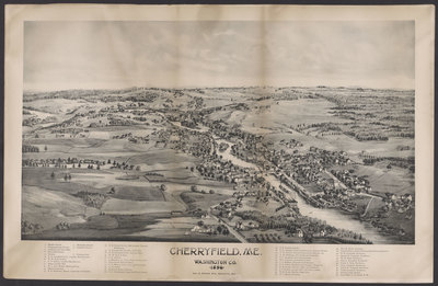
Cherryfield, Me. Washington Co. 1896
Preview
Cherryfield, Maine - hi-res
Publication Date
1896
County
Washington
Artist
Unknown
Publisher
George E. Norris
Dimensions
45 x 68 cm
Owner
Maine Historic Preservation Commission
Additional Institutional Copies
Population of City/Town at Time of Publication
1,787
Description of City/Town
Located on both sides of the Narraguagus River, Cherryfield became the site of many water-powered industries, including a grist mill, a planing mill, a sash, door and blind factory, and several sawmills. These sawmills annually produced $400,000 in lumber and $30,000 worth of shingles. Lumber and shingles were transported by river on rafts to Milbridge, where they were shipped to various ports.
Usage Rights
As a publicly supported institution, the Maine Historic Preservation Commission generally does not own rights to material in its collections. Therefore, it does not charge permission fees for the use of such material and cannot give or deny permission to publish or otherwise distribute material in its collections. The copyright and related rights status of the items in this collection have not been evaluated. While many of these images may be in the public domain, it is up to you to determine and satisfy copyright or other use restrictions when publishing or otherwise distributing materials found in this collection. You are free to use an item in any way that is permitted by the copyright and related rights legislation that applies to your use.
Recommended Citation
Courtesy of the Maine Historic Preservation Commission.
Keywords
Cherryfield, Washington County, Maine, Bird's eye, View, Map