Map Title
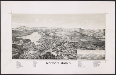
Monson, Maine.
Preview
Monson, Maine - hi-res
Publication Date
1889
County
Piscataquis
Artist
George E. Norris
Lithographer
Burleigh Litho.
Publisher
George E. Norris
Dimensions
47 x 74.3 cm
Owner
Maine Historic Preservation Commission
Additional Institutional Copies
Norman B. Leventhal Map & Education Center at the Boston Public Library
Library of Congress
Population of City/Town at Time of Publication
827
Description of City/Town
At the village near the centre of town are lumber-mills and a grist-mill. Doughty Hill is the highest elevation of land. Much of the surface is low and stony, and has never been cleared, but perhaps half the area is a light, loamy soil, of an excellent quality for the crops raised—hay, oats, wheat and potatoes. The principal business is slate mining, in which four or more companies are engaged.
A Gazetteer of the State of Maine, George J. Varney, 1881, 1886
Usage Rights
As a publicly supported institution, the Maine Historic Preservation Commission generally does not own rights to material in its collections. Therefore, it does not charge permission fees for the use of such material and cannot give or deny permission to publish or otherwise distribute material in its collections. The copyright and related rights status of the items in this collection have not been evaluated. While many of these images may be in the public domain, it is up to you to determine and satisfy copyright or other use restrictions when publishing or otherwise distributing materials found in this collection. You are free to use an item in any way that is permitted by the copyright and related rights legislation that applies to your use.
Recommended Citation
Courtesy of the Maine Historic Preservation Commission.
Keywords
Monson, Piscataquis County, Maine, Bird's eye, View, Map